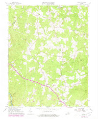
1966 Map of Storck
USGS Topo · Published 1978About this map
The boundary between Fauquier and Stafford counties is defined by the headwaters and drainages of central Virginia, where the Rappahannock River edges the southwestern corner of the landscape. This area is characterized by a series of localized road junctions and crossroads settlements, including Hartwood, Storck, and Dodds Corner. The map reveals a community structured around small rural churches such as Richland Ch and Rock Hill Ch, alongside the Glen Haven Memory Gardens. The topography is intricately carved by numerous waterways like Aquia Creek and Potomac Run, which flow through the wooded terrain. Revisions from the late 1970s, shown in purple, capture residential growth and new infrastructure like the Radio Tower near Glendie and the Hartwood Airport, illustrating the gradual shift from traditional farmland toward modern development.
Find a feature on this map
34 named features on this map. Tap any name to fly to it.
Don’t see what you’re looking for? This feature index may not catch every label — zoom into the map to look around manually.
Map Details
Editions of this 1966 Storck Map
4 editions found
Other maps of this area

1887 · Spottsylvania
USGS Topo · 1:125,000

1889 · Fredericksburg
USGS Topo · 1:125,000

1890 · Mt. Vernon
USGS Topo · 1:125,000

1891 · Mt. Vernon
USGS Topo · 1:125,000

1892 · Fredericksburg
USGS Topo · 1:125,000

1892 · Spottsylvania
USGS Topo · 1:125,000

1894 · Warrenton
USGS Topo · 1:125,000

1894 · Fredericksburg
USGS Topo · 1:125,000

1894 · Mt. Vernon
USGS Topo · 1:125,000

1897 · Mt. Vernon
USGS Topo · 1:125,000