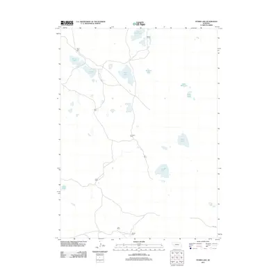
2011 Map of Storm Lake
USGS Topo · Published 2011About this map
Storm Lake Ranch and a network of family-named cattle operations define this high-plains landscape in Garden County. The terrain is characterized by a high density of alkali and freshwater basins typical of the Nebraska Sandhills, ranging from East Valley Lake in the north to Roach Lake in the southwest. A decentralized settlement pattern is evident through the placement of Archer Ranch, Reed Ranch, and Stille Ranch, which are connected by primitive roads and trails rather than a formal highway system. This 2011 survey captures the area's enduring reliance on groundwater and ranching, with features like Windmill Lake and Goose Lake serving as vital landmarks in an otherwise open range. The sparse infrastructure, limited largely to Road 106 in the southeast, highlights the isolation of these homesteads from larger regional centers.
Find a feature on this map
19 named features on this map. Tap any name to fly to it.
Don’t see what you’re looking for? This feature index may not catch every label — zoom into the map to look around manually.
Map Details
Editions of this 2011 Storm Lake Map
This is the sole edition of this map. No revisions or reprints were ever made.
Other maps of this area

1896 · Browns Creek
USGS Topo · 1:125,000

1899 · Browns Creek
USGS Topo · 1:125,000

1949 · Lynn
USGS Topo · 1:62,500

1950 · Storm Lake
USGS Topo · 1:62,500

1954 · Scottsbluff
USGS Topo · 1:250,000

1958 · Scottsbluff
USGS Topo · 1:250,000

1965 · Broadwater NE
USGS Topo · 1:24,000

1971 · Richardson Lake
USGS Topo · 1:24,000
1971 · Tar Valley
USGS Topo · 1:24,000

1985 · Crescent Lake
USGS Topo · 1:100,000