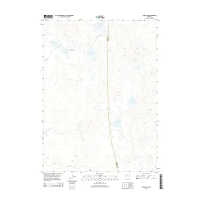
2014 Map of Storm Lake
USGS Topo · Published 2014About this map
Storm Lake and a constellation of shallow alkali waters dominate this section of the Nebraska Sandhills, straddling the boundary between Morrill and Garden counties. The landscape is defined by its internal drainage basins, where water collects in depressions such as Goose Lake, Clark Lake, and Windmill Lake. This hydrology creates a pattern of dispersed wetlands and ephemeral pools characteristic of the region's semi-arid environment. Human activity is marked by a sparse network of section-line roads, including Road 118 and Communal Rd, which provide access to this ranching country. To the south, the terrain descends toward Tar Valley, while scattered named landmarks like Moffit Lake and Sand Lake serve as primary points of orientation across the undulating dunes and interdunal swales.
Find a feature on this map
16 named features on this map. Tap any name to fly to it.
Don’t see what you’re looking for? This feature index may not catch every label — zoom into the map to look around manually.
Map Details
Editions of this 2014 Storm Lake Map
This is the sole edition of this map. No revisions or reprints were ever made.
Other maps of this area

1896 · Browns Creek
USGS Topo · 1:125,000

1899 · Browns Creek
USGS Topo · 1:125,000

1949 · Lynn
USGS Topo · 1:62,500

1950 · Storm Lake
USGS Topo · 1:62,500

1954 · Scottsbluff
USGS Topo · 1:250,000

1958 · Scottsbluff
USGS Topo · 1:250,000

1965 · Broadwater NE
USGS Topo · 1:24,000

1971 · Richardson Lake
USGS Topo · 1:24,000
1971 · Tar Valley
USGS Topo · 1:24,000

1985 · Crescent Lake
USGS Topo · 1:100,000