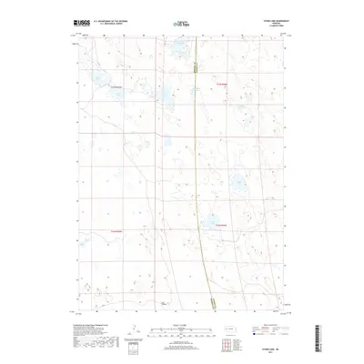
2017 Map of Storm Lake
USGS Topo · Published 2017About this map
Storm Lake and a dense cluster of sandhill ponds characterize this portion of the Nebraska panhandle, where the boundary between Morrill Co and Garden Co runs through a landscape defined by closed basins and ephemeral water. The topography is dominated by the intricate drainage and depression patterns typical of the region, including named features like Tar Valley in the south and the twin basins of North Rapp Lake and Rapp Lake to the east. Human presence is sparse, indicated primarily by the section lines of the Public Land Survey System and minor roads like RD 98. Smaller bodies of water such as Clark Lake, Goose Lake, and Windmill Lake punctuate the terrain, illustrating the critical role of surface water in this arid ranching environment. The reliance on these intermittent sources is evident in the naming of localized catchments like Moffit Lake and Sand Lake.
Find a feature on this map
18 named features on this map. Tap any name to fly to it.
Don’t see what you’re looking for? This feature index may not catch every label — zoom into the map to look around manually.
Map Details
Editions of this 2017 Storm Lake Map
This is the sole edition of this map. No revisions or reprints were ever made.
Other maps of this area

1896 · Browns Creek
USGS Topo · 1:125,000

1899 · Browns Creek
USGS Topo · 1:125,000

1949 · Lynn
USGS Topo · 1:62,500

1950 · Storm Lake
USGS Topo · 1:62,500

1954 · Scottsbluff
USGS Topo · 1:250,000

1958 · Scottsbluff
USGS Topo · 1:250,000

1965 · Broadwater NE
USGS Topo · 1:24,000

1971 · Richardson Lake
USGS Topo · 1:24,000
1971 · Tar Valley
USGS Topo · 1:24,000

1985 · Crescent Lake
USGS Topo · 1:100,000