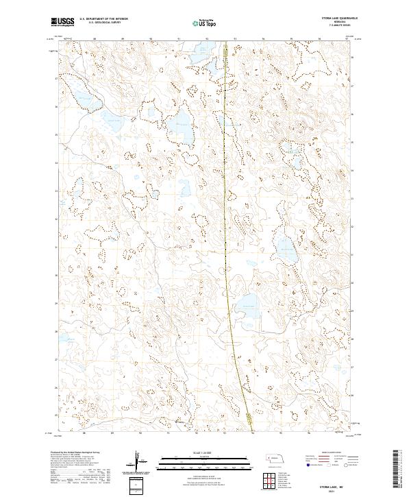
2021 Map of Storm Lake
USGS Topo · Published 2021About this map
Storm Lake and a series of smaller alkali and freshwater basins define this high plains landscape along the Morrill Co and Garden Co line. This 2021 survey reveals a territory dominated by internal drainage, where water bodies like Goose Lake, East Valley Lake, and the expansive Sand Lake are scattered across the terrain. The lack of structured irrigation or significant road networks, apart from RD 98 at the southern edge, suggests a land primarily used for ranching and grazing. The topography is characterized by subtle depressions and rises, with Tar Valley providing one of the few named landforms in an area otherwise distinguished by its isolated lakes, including North Rapp Lake, Rapp Lake, and Moffit Lake. This detailed hydrographic record is essential for understanding the shifting wetland patterns and water table of the Nebraska Sandhills.
Find a feature on this map
18 named features on this map. Tap any name to fly to it.
Don’t see what you’re looking for? This feature index may not catch every label — zoom into the map to look around manually.
Map Details
Editions of this 2021 Storm Lake Map
This is the sole edition of this map. No revisions or reprints were ever made.
Other maps of this area

1896 · Browns Creek
USGS Topo · 1:125,000

1899 · Browns Creek
USGS Topo · 1:125,000

1949 · Lynn
USGS Topo · 1:62,500

1950 · Storm Lake
USGS Topo · 1:62,500

1954 · Scottsbluff
USGS Topo · 1:250,000

1958 · Scottsbluff
USGS Topo · 1:250,000

1965 · Broadwater NE
USGS Topo · 1:24,000

1971 · Richardson Lake
USGS Topo · 1:24,000
1971 · Tar Valley
USGS Topo · 1:24,000

1985 · Crescent Lake
USGS Topo · 1:100,000