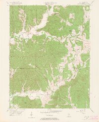
1956 Map of Story
USGS Topo · Published 1965About this map
Brown County State Park dominates the northern landscape of this mid-century Indiana survey, where the rugged topography of the southern hills dictated a winding network of roads and scattered rural settlements. Small communities like Story and Christiansburg serve as local hubs in this deeply dissected terrain, characterized by a series of prominent ridges such as Oak Ridge and Pruitt Ridge. The map reveals the historical imprint of the Old Indian Treaty Boundary Line, which cuts diagonally across the townships, influencing property lines and road placements long after the treaty's inception. Genealogists will find a wealth of specific local landmarks, including the Van Buren High Sch and numerous family burial grounds like Polly Hill Cem and Moffitt Cem. In the south, the village of Houston sits near the Houston Lookout Tower, marking a high point overlooking the Little Salt Creek drainage system.
Find a feature on this map
59 named features on this map. Tap any name to fly to it.
Don’t see what you’re looking for? This feature index may not catch every label — zoom into the map to look around manually.
Map Details
Editions of this 1956 Story Map
2 editions found

Other maps of this area

1934 · Bedford
USGS Topo · 1:48,000

1937 · Bedford
USGS Topo · 1:62,500

1942 · Franklin
USGS Topo · 1:125,000

1946 · Belmont
USGS Topo · 1:24,000

1947 · Nashville
USGS Topo · 1:24,000

1947 · Elkinsville
USGS Topo · 1:24,000

1948 · New Bellsville
USGS Topo · 1:24,000

1948 · Waymansville
USGS Topo · 1:24,000

1949 · Nashville
USGS Topo · 1:24,000

1950 · Belmont
USGS Topo · 1:24,000