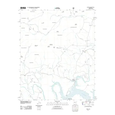
2011 Map of Story
USGS Topo · Published 2011About this map
Lake Ouachita dominates the southern landscape of this Montgomery County quadrangle, where the Ouachita River feeds into the reservoir near the settlement of Washita. This area is characterized by numerous family-named peaks and ridges, including Brantley Mountain, Pot Mountain, and Big Round Top Mountain. The community of Story serves as a local hub, featuring the Story Post Office and several rural thoroughfares like Story Creek Rd. Genealogists and local historians will find several burial sites noted, such as Reed Cemetery and both the East Washita Cemetery and West Washita Cemetery. Numerous watercourses like Muddy Creek and Story Creek carve through the terrain, illustrating the complex drainage patterns of the region. The map also identifies smaller locales like Gibbs and the waterfront access at BuddysLanding, providing a detailed view of the rural settlement patterns along the mountain foothills.
Find a feature on this map
55 named features on this map. Tap any name to fly to it.
Don’t see what you’re looking for? This feature index may not catch every label — zoom into the map to look around manually.
Map Details
Editions of this 2011 Story Map
This is the sole edition of this map. No revisions or reprints were ever made.
Other maps of this area

1890 · Mount Ida
USGS Topo · 1:125,000

1890 · Hot Springs
USGS Topo · 1:125,000

1894 · Hot Springs
USGS Topo · 1:125,000

1955 · Little Rock
USGS Topo · 1:250,000

1956 · Little Rock
USGS Topo · 1:250,000

1959 · Mount Ida
USGS Topo · 1:62,500

1960 · Little Rock
USGS Topo · 1:250,000

1960 · Gravelly
USGS Topo · 1:62,500

1962 · Fannie
USGS Topo · 1:24,000

1962 · Mc Graw Mountain
USGS Topo · 1:24,000