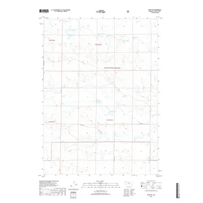
2017 Map of Story NE
USGS Topo · Published 2017About this map
Oglala National Grassland dominates this high plains landscape in northern Sioux County, defined by a network of intermittent drainages and ranching-related water management. The terrain is marked by seasonal flows such as Indian Cr and Antelope Cr, which are punctuated by numerous small reservoirs named for local families and landmarks. The prevalence of features like Henry Reservoir Number 1, Merlin Mader Reservoir Number 1, and Jordan Reservoir illustrates the critical role of water storage in this arid livestock-raising region. Transportation is limited to a few arterial gravel routes, including Edgemont Rd and Montrose Rd, which cross the sparse topography. The map provides a clear look at the land use patterns and water engineering required to sustain agriculture within the national grassland boundaries during the early 21st century.
Find a feature on this map
20 named features on this map. Tap any name to fly to it.
Don’t see what you’re looking for? This feature index may not catch every label — zoom into the map to look around manually.
Map Details
Editions of this 2017 Story NE Map
This is the sole edition of this map. No revisions or reprints were ever made.
Other maps of this area

1902 · Edgemont
USGS Topo · 1:125,000

1955 · Hot Springs
USGS Topo · 1:250,000

1955 · Alliance
USGS Topo · 1:250,000

1957 · Alliance
USGS Topo · 1:250,000

1958 · Alliance
USGS Topo · 1:250,000

1980 · Montrose
USGS Topo · 1:24,000
1980 · Story
USGS Topo · 1:24,000

1980 · Five Points
USGS Topo · 1:24,000
1980 · Story NE
USGS Topo · 1:24,000
1980 · Warbonnet Ranch
USGS Topo · 1:24,000