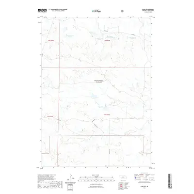
2021 Map of Story NE
USGS Topo · Published 2021About this map
Oglala National Grassland dominates this section of Sioux County, where the high plains are shaped by a complex system of livestock reservoirs and ephemeral drainages. The landscape is characterized by a network of water management features, including the multiple Mader Reservoir Number 1, Mader Reservoir Number 2, and Mader Reservoir Number 3 sites, as well as the Merlin Mader Reservoir Number 1. These cattle ponds and reservoirs are tied to the local ranching economy, situated along drainages like Antelope Cr and Indian Cr. Travel through this open range is guided by a few primary routes such as Edgemont Rd and Montrose Rd, which connect the scattered water resources and grazing lands. The map also captures the headwaters of Squaw Cr and Hat Cr, illustrating the hydrological patterns of the Nebraska Panhandle.
Find a feature on this map
18 named features on this map. Tap any name to fly to it.
Don’t see what you’re looking for? This feature index may not catch every label — zoom into the map to look around manually.
Map Details
Editions of this 2021 Story NE Map
This is the sole edition of this map. No revisions or reprints were ever made.
Other maps of this area

1902 · Edgemont
USGS Topo · 1:125,000

1955 · Hot Springs
USGS Topo · 1:250,000

1955 · Alliance
USGS Topo · 1:250,000

1957 · Alliance
USGS Topo · 1:250,000

1958 · Alliance
USGS Topo · 1:250,000

1980 · Montrose
USGS Topo · 1:24,000
1980 · Story
USGS Topo · 1:24,000

1980 · Five Points
USGS Topo · 1:24,000
1980 · Story NE
USGS Topo · 1:24,000
1980 · Warbonnet Ranch
USGS Topo · 1:24,000