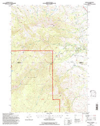
1993 Map of Story
USGS Topo · Published 1997About this map
Story sits at the foot of the Bighorn Mountains in the early 1990s, where the winding waters of North Piney Creek and South Piney Creek converge. This survey documents a landscape where historical conflict and modern conservation intersect. Near the Sheridan and Johnson County line, the Wagon Box Battle Monument marks the site of an 1867 engagement between the U.S. Army and Lakota Sioux. Nearby Ruins and the Penrose Trail suggest the deep layers of transit and settlement through the Piney Divide. The eastern half of the map shows the community's development through institutional footprints like the State Fish Hatchery and Thorn Rider Camp, while the western portion is dominated by the steep ascent of Moncreiffe Ridge into the Bighorn National Forest.
Find a feature on this map
39 named features on this map. Tap any name to fly to it.
Don’t see what you’re looking for? This feature index may not catch every label — zoom into the map to look around manually.
Map Details
Editions of this 1993 Story Map
This is the sole edition of this map. No revisions or reprints were ever made.
Other maps of this area

1895 · Dayton
USGS Topo · 1:125,000

1899 · Cloud peak
USGS Topo · 1:125,000

1900 · Fort McKinney
USGS Topo · 1:125,000

1901 · Cloud Peak
USGS Topo · 1:125,000

1901 · Dayton
USGS Topo · 1:125,000

1903 · Fort McKinney
USGS Topo · 1:125,000

1909 · Sheridan
USGS Topo · 1:125,000

1911 · Sheridan
USGS Topo · 1:125,000

1955 · Sheridan
USGS Topo · 1:250,000

1958 · Sheridan
USGS Topo · 1:250,000