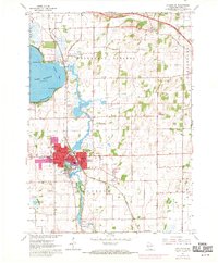
1961 Map of Stoughton
USGS Topo · Published 1970About this map
The Yahara River flows through the heart of this landscape, connecting Lake Kegonsa to the industrial and civic center of Stoughton. This 1961 survey, photorevised in 1969, illustrates a period of significant urban expansion, with purple-tinted areas marking new developments near the Yahara Sch and the Stoughton Airfield. The river’s influence is central to the area's layout, from the recreational shores of Williams Bay to the small settlement of Dunkirk further downstream.
Find a feature on this map
41 named features on this map. Tap any name to fly to it.
Don’t see what you’re looking for? This feature index may not catch every label — zoom into the map to look around manually.
Map Details
Editions of this 1961 Stoughton Map
3 editions found
Other maps of this area

1889 · Evansville
USGS Topo · 1:62,500

1890 · Madison
USGS Topo · 1:62,500

1890 · Sun Prairie
USGS Topo · 1:62,500

1890 · Stoughton
USGS Topo · 1:62,500

1892 · Madison
USGS Topo · 1:62,500

1894 · Evansville
USGS Topo · 1:62,500

1896 · Sun Prairie
USGS Topo · 1:62,500

1904 · Madison
USGS Topo · 1:62,500

1905 · Sun Prairie
USGS Topo · 1:62,500

1906 · Evansville
USGS Topo · 1:62,500