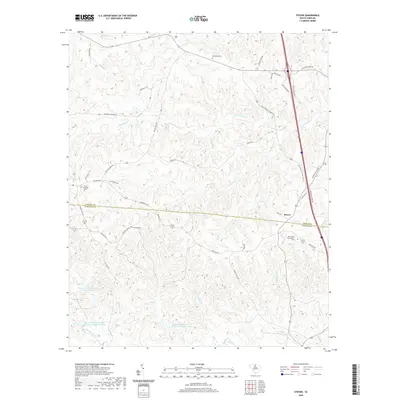
2020 Map of Stover
USGS Topo · Published 2020About this map
Stover sits at a geographic crossroads along the boundary of Chester Co and Fairfield Co in this 2020 South Carolina survey. The landscape is defined by the headwaters and intricate drainages of Big Wateree Creek, which is fed by several named tributaries including Willow Swamp Br and Stover Cr. For genealogists and local historians, the sheet preserves the locations of several burial grounds, such as the Gold Mine Cem in the north and the Richmond Covenanter Cem to the south. Historically named thoroughfares like Cornwallis Rd and Old Catholic Church Rd trace the path of older routes through the Piedmont. Significant water management is evident in the Wateree Cr Conservation District Reservoir and several watershed structures, illustrating the modern rural development of this central South Carolina region.
Find a feature on this map
47 named features on this map. Tap any name to fly to it.
Don’t see what you’re looking for? This feature index may not catch every label — zoom into the map to look around manually.
Map Details
Editions of this 2020 Stover Map
This is the sole edition of this map. No revisions or reprints were ever made.
Other maps of this area

1904 · Columbia
USGS Topo · 1:125,000

1941 · Spartanburg
USGS Topo · 1:250,000

1942 · Camden
USGS Topo · 1:125,000

1953 · Spartanburg
USGS Topo · 1:250,000

1960 · Spartanburg
USGS Topo · 1:250,000

1963 · Spartanburg
USGS Topo · 1:250,000

1964 · Spartanburg
USGS Topo · 1:250,000

1968 · Blackstock
USGS Topo · 1:24,000
1969 · Fort Lawn
USGS Topo · 1:24,000
1969 · Great Falls
USGS Topo · 1:24,000