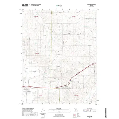
2017 Map of Strafford
USGS Topo · Published 2017About this map
Strafford serves as a central hub on this landscape, positioned along the historical corridor of Old Route 66 and the Burlington Northern Santa Fe railroad. The geography is defined by the headwaters of several significant Missouri waterways, including the Pomme de Terre River, the James River, and the Little Sac River. These drainage patterns divide the terrain into distinct ridges and hollows, such as Millan Hollow, creating a complex network of small branches like Polk Spring Br and Jarrett Br. Smaller settlements and locales like Caddo, Holman, and Red Top are scattered throughout the northeastern and eastern portions of the map, often situated near family-named landmarks and cemeteries like Bumgarner Cem and Welch Cem. The presence of the Cuinche Airport near the southern boundary reflects the modern infrastructure supporting this rural Greene and Webster County border region.
Find a feature on this map
115 named features on this map. Tap any name to fly to it.
Don’t see what you’re looking for? This feature index may not catch every label — zoom into the map to look around manually.
Map Details
Editions of this 2017 Strafford Map
This is the sole edition of this map. No revisions or reprints were ever made.
Other maps of this area

1884 · Springfield
USGS Topo · 1:125,000

1886 · Springfield
USGS Topo · 1:125,000

1937 · Galloway
USGS Topo · 1:24,000

1937 · Ozark
USGS Topo · 1:48,000

1939 · Fordland
USGS Topo · 1:62,500

1942 · Fordland
USGS Topo · 1:62,500

1943 · Ozark
USGS Topo · 1:62,500

1945 · Ozark
USGS Topo · 1:62,500

1946 · Bassville
USGS Topo · 1:24,000

1946 · Niangua
USGS Topo · 1:62,500