
1967 Map of Straight
USGS Topo · Published 1968About this map
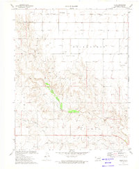
Wild Horse Lake sits as a prominent central feature within the Friendship and Voorhees districts of the Oklahoma Panhandle. This 1967 survey documents a landscape defined by the mid-century energy economy, where a dense network of Gas Wells and an occasional Oil Well are connected by a branching Pipeline system. Near the southern edge of the map, the small settlement of Straight is situated along a light-duty road, supported by the Straight Landing Field to its east. The topography is relatively level, broken primarily by the drainage of Pony Creek in the southwest corner and several scattered depressions that collect water across the high plains. The transition between Texas County, Oklahoma, and Stevens County, Kansas, is clearly marked, reflecting the importance of this border region for local land management and resource extraction during the era.
Find a feature on this map
12 named features on this map. Tap any name to fly to it.
Don’t see what you’re looking for? This feature index may not catch every label — zoom into the map to look around manually.
Map Details
Editions of this 1967 Straight Map
This is the sole edition of this map. No revisions or reprints were ever made.
Other maps of this area

1954 · Perryton
USGS Topo · 1:250,000

1955 · Dodge City
USGS Topo · 1:250,000

1958 · Perryton
USGS Topo · 1:250,000

1958 · Dodge City
USGS Topo · 1:250,000

1959 · Dodge City
USGS Topo · 1:250,000

1967 · Straight NE
USGS Topo · 1:24,000

1967 · Straight SW
USGS Topo · 1:24,000

1967 · Optima
USGS Topo · 1:24,000

1973 · Hough NE
USGS Topo · 1:24,000
1973 · Hough
USGS Topo · 1:24,000