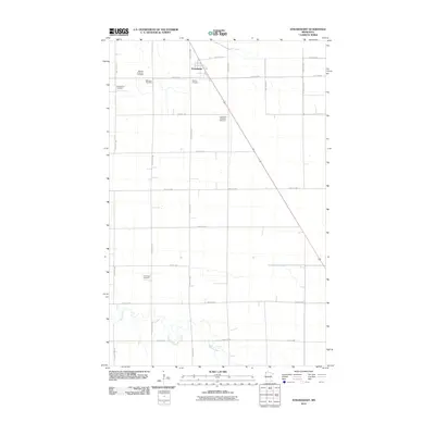
2010 Map of Strandquist
USGS Topo · Published 2010About this map
Strandquist serves as the focal point of this northern Minnesota landscape, where the town site is situated at the intersection of a sprawling rural grid and the railroad corridor. The area's cultural history is deeply reflected in its distributed burial grounds, which point to the diverse heritage of early settlers. Notable sites include the Mission Covenant Cemetery, Bethesda Cemetery, and English Cemetery, alongside the Augustana Lutheran Cemetery and Norwegian Cemetery. These labels suggest a settlement pattern where immigrant congregations established local centers across the prairie. The southern portion of the map is defined by the winding course of the Middle River, which cuts across the rigid section lines of the township. This 2010 survey provides a clear view of the regional road network, from major arteries like County Hwy 115 and County Hwy 29 to the numbered gravel roads that facilitate the agricultural life of the Red River Valley region.
Find a feature on this map
25 named features on this map. Tap any name to fly to it.
Don’t see what you’re looking for? This feature index may not catch every label — zoom into the map to look around manually.
Map Details
Editions of this 2010 Strandquist Map
This is the sole edition of this map. No revisions or reprints were ever made.
Other maps of this area

1919 · Pelan
USGS Topo · 1:62,500

1952 · Thief River Falls
USGS Topo · 1:250,000

1956 · Thief River Falls
USGS Topo · 1:250,000

1956 · Karlstad
USGS Topo · 1:62,500

1956 · Florian
USGS Topo · 1:62,500

1957 · Thief River Falls
USGS Topo · 1:250,000

1957 · Newfolden
USGS Topo · 1:62,500

1957 · Pelan
USGS Topo · 1:62,500

1967 · Thief River Falls
USGS Topo · 1:250,000
1982 · Florian SE
USGS Topo · 1:24,000