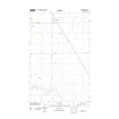
2013 Map of Strandquist
USGS Topo · Published 2013About this map
Strandquist sits at the heart of this Marshall County survey, where a strict grid of section roads like 190th Ave NW and 420th St NW organizes the prairie landscape. The area is characterized by its numerous small burial grounds, which reflect the early ethnic and denominational clusters of the region, including Augustana Lutheran Cem, Mission Covenant Cem, and the Norwegian Cem. These sites, along with the Bethesda Cem and English Cem, offer significant geographic markers for genealogical research in this rural corridor. In the southern portion of the map, the meandering path of the Middle River breaks the geometry of the surrounding farmland, while the engineering of the Judicial Ditch Number Nineteen in the northeast demonstrates the historical efforts to manage drainage across these flat northwestern Minnesota plains.
Find a feature on this map
24 named features on this map. Tap any name to fly to it.
Don’t see what you’re looking for? This feature index may not catch every label — zoom into the map to look around manually.
Map Details
Editions of this 2013 Strandquist Map
This is the sole edition of this map. No revisions or reprints were ever made.
Other maps of this area

1919 · Pelan
USGS Topo · 1:62,500

1952 · Thief River Falls
USGS Topo · 1:250,000

1956 · Thief River Falls
USGS Topo · 1:250,000

1956 · Karlstad
USGS Topo · 1:62,500

1956 · Florian
USGS Topo · 1:62,500

1957 · Thief River Falls
USGS Topo · 1:250,000

1957 · Newfolden
USGS Topo · 1:62,500

1957 · Pelan
USGS Topo · 1:62,500

1967 · Thief River Falls
USGS Topo · 1:250,000
1982 · Florian SE
USGS Topo · 1:24,000