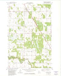
1982 Map of Strandquist
USGS Topo · Published 1982About this map
The village of Strandquist serves as the primary hub in this Marshall County landscape, situated along the Soo Line railroad which cuts diagonally through the townships of Lincoln and West Valley. The settlement pattern is defined by a heavy presence of ethnic and denominational burial grounds, including the Mission Covenant Cem, Bethesda Cem, English Cem, and the Norwegian Cem, reflecting the diverse immigrant heritage of the Red River Valley region. To the north, the East Park State Wildlife Management Area marks a transition to managed natural spaces, while the southern reaches are drained by the winding Middle River and an extensive network of drainage infrastructure like Judicial Ditch No 19. This 1982 record documents a well-established agricultural grid, supported by local landmarks such as the Roadside Park and a rural Townhall.
Find a feature on this map
19 named features on this map. Tap any name to fly to it.
Don’t see what you’re looking for? This feature index may not catch every label — zoom into the map to look around manually.
Map Details
Editions of this 1982 Strandquist Map
This is the sole edition of this map. No revisions or reprints were ever made.
Other maps of this area

1919 · Pelan
USGS Topo · 1:62,500

1952 · Thief River Falls
USGS Topo · 1:250,000

1956 · Thief River Falls
USGS Topo · 1:250,000

1956 · Karlstad
USGS Topo · 1:62,500

1956 · Florian
USGS Topo · 1:62,500

1957 · Thief River Falls
USGS Topo · 1:250,000

1957 · Newfolden
USGS Topo · 1:62,500

1957 · Pelan
USGS Topo · 1:62,500

1967 · Thief River Falls
USGS Topo · 1:250,000
1982 · Florian SE
USGS Topo · 1:24,000