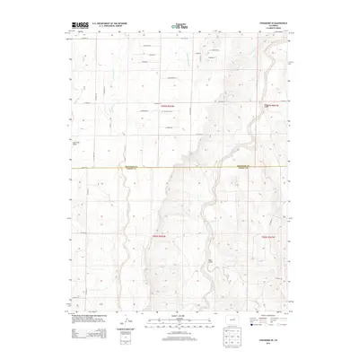
2013 Map of Strasburg SE
USGS Topo · Published 2013About this map
W Bijou Cr carves a significant north-south path through this High Plains landscape, defining the local hydrology alongside its tributaries. The terrain is marked by distinctive drainages such as Mule Gulch, Lone Tree Gulch, and East Gulch, which illustrate the erosion patterns characteristic of this part of the Colorado interior. The map captures the interface between Arapahoe and Elbert Counties, showing a transition from established county roads to more modern residential planning in the northern sections.
Find a feature on this map
36 named features on this map. Tap any name to fly to it.
Don’t see what you’re looking for? This feature index may not catch every label — zoom into the map to look around manually.
Map Details
Editions of this 2013 Strasburg SE Map
This is the sole edition of this map. No revisions or reprints were ever made.
Other maps of this area

1953 · Denver
USGS Topo · 1:250,000

1955 · Strasburg NW
USGS Topo · 1:24,000

1955 · Strasburg
USGS Topo · 1:24,000

1956 · Byers
USGS Topo · 1:24,000

1957 · Denver
USGS Topo · 1:250,000

1958 · Denver
USGS Topo · 1:250,000

1960 · Denver
USGS Topo · 1:250,000
1961 · Strasburg SW
USGS Topo · 1:24,000
1969 · Strasburg SE
USGS Topo · 1:24,000
1969 · Byers SW
USGS Topo · 1:24,000