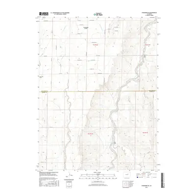
2016 Map of Strasburg SE
USGS Topo · Published 2016About this map
Comanche Creek and its tributary, Little Comanche Cr, define the drainage patterns of this High Plains landscape southeast of Strasburg. The terrain is marked by several prominent geological depressions, including Lone Tree Gulch in the west and Mule Gulch in the northeast. This 2016 survey captures the area as residential development began pushing into traditionally agricultural sections of the Colorado plains. A regular grid of county roads and named residential avenues, such as Belleview Ave and Knudtson Rd, provides access across the shifting elevation lines. The boundary between Arapahoe Co and Elbert Co bisects the map, showing the jurisdictional division of these rangelands as they transition toward suburban expansion.
Find a feature on this map
31 named features on this map. Tap any name to fly to it.
Don’t see what you’re looking for? This feature index may not catch every label — zoom into the map to look around manually.
Map Details
Editions of this 2016 Strasburg SE Map
This is the sole edition of this map. No revisions or reprints were ever made.
Other maps of this area

1953 · Denver
USGS Topo · 1:250,000

1955 · Strasburg NW
USGS Topo · 1:24,000

1955 · Strasburg
USGS Topo · 1:24,000

1956 · Byers
USGS Topo · 1:24,000

1957 · Denver
USGS Topo · 1:250,000

1958 · Denver
USGS Topo · 1:250,000

1960 · Denver
USGS Topo · 1:250,000
1961 · Strasburg SW
USGS Topo · 1:24,000
1969 · Strasburg SE
USGS Topo · 1:24,000
1969 · Byers SW
USGS Topo · 1:24,000