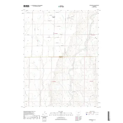
2019 Map of Strasburg SE
USGS Topo · Published 2019About this map
Comanche Creek and its tributary Little Comanche Cr drain the high plains of the Arapahoe and Elbert county line, carving through a landscape defined by expansive township and range sections. This 2019 survey captures the interface between traditional agricultural tracts and the encroaching residential grid extending from the north, where names like E Belleview Ave and E Prentice Pl appear alongside long-standing local arteries such as Strasburg Rd and Kingsburg Rd. To the east, the terrain becomes more defined by natural drainages like W Bijou Cr and Mule Gulch, while the southwestern quadrant is marked by the winding path of Lone Tree Gulch. This modern record illustrates the persistence of the section-line road network in shaping rural transit and property boundaries.
Find a feature on this map
43 named features on this map. Tap any name to fly to it.
Don’t see what you’re looking for? This feature index may not catch every label — zoom into the map to look around manually.
Map Details
Editions of this 2019 Strasburg SE Map
This is the sole edition of this map. No revisions or reprints were ever made.
Other maps of this area

1953 · Denver
USGS Topo · 1:250,000

1955 · Strasburg NW
USGS Topo · 1:24,000

1955 · Strasburg
USGS Topo · 1:24,000

1956 · Byers
USGS Topo · 1:24,000

1957 · Denver
USGS Topo · 1:250,000

1958 · Denver
USGS Topo · 1:250,000

1960 · Denver
USGS Topo · 1:250,000
1961 · Strasburg SW
USGS Topo · 1:24,000
1969 · Strasburg SE
USGS Topo · 1:24,000
1969 · Byers SW
USGS Topo · 1:24,000