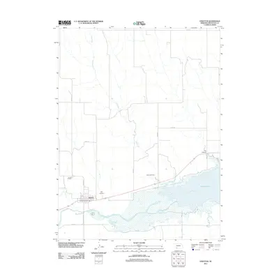
2011 Map of Stratton
USGS Topo · Published 2011About this map
The village of Stratton serves as the primary hub of this Hitchcock County landscape, situated where the Republican River begins its transition into the vast waters of Swanson Lake. The community's infrastructure is anchored by the Stratton Post Office and its residential grid, while the Stratton Cemetery lies just to the northwest along Beaver Ave. The map illustrates a landscape shaped by water management and natural drainage, from the Diehl Lake Dam to the winding course of Camp Creek as it flows south toward the river valley.
Find a feature on this map
22 named features on this map. Tap any name to fly to it.
Don’t see what you’re looking for? This feature index may not catch every label — zoom into the map to look around manually.
Map Details
Editions of this 2011 Stratton Map
This is the sole edition of this map. No revisions or reprints were ever made.
Other maps of this area

1954 · McCook
USGS Topo · 1:250,000

1957 · McCook
USGS Topo · 1:250,000

1958 · McCook
USGS Topo · 1:250,000

1962 · Trenton
USGS Topo · 1:24,000

1962 · Trenton SW
USGS Topo · 1:24,000
1962 · Max SE
USGS Topo · 1:24,000
1962 · Trenton SE
USGS Topo · 1:24,000

1962 · Stratton
USGS Topo · 1:24,000

1962 · Max NE
USGS Topo · 1:24,000

1973 · Palisade
USGS Topo · 1:24,000