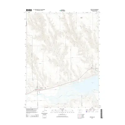
2014 Map of Stratton
USGS Topo · Published 2014About this map
The village of Stratton sits at the northern edge of the Republican River valley, a landscape defined by the intersection of high plains agriculture and critical water resources. This 2014 survey captures the community and its surrounding geography just north of the massive Swanson Lake reservoir. The local terrain is deeply incised by drainage systems such as Camp Cr and Muddy Cr, which flow through named landforms like Hay Canyon and Macklin Canyon.
Find a feature on this map
28 named features on this map. Tap any name to fly to it.
Don’t see what you’re looking for? This feature index may not catch every label — zoom into the map to look around manually.
Map Details
Editions of this 2014 Stratton Map
This is the sole edition of this map. No revisions or reprints were ever made.
Other maps of this area

1954 · McCook
USGS Topo · 1:250,000

1957 · McCook
USGS Topo · 1:250,000

1958 · McCook
USGS Topo · 1:250,000

1962 · Trenton
USGS Topo · 1:24,000

1962 · Trenton SW
USGS Topo · 1:24,000
1962 · Max SE
USGS Topo · 1:24,000
1962 · Trenton SE
USGS Topo · 1:24,000

1962 · Stratton
USGS Topo · 1:24,000

1962 · Max NE
USGS Topo · 1:24,000

1973 · Palisade
USGS Topo · 1:24,000