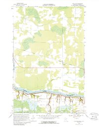
1968 Map of Stratton
USGS Topo · Published 1988About this map
The Rainy River forms a natural and political boundary in this late 1960s survey, separating the Koochiching Co region of Minnesota from Ontario, Canada. This international borderland is defined by a landscape of low-lying wetlands and managed timber, with the southern portion of the map dominated by the northern reaches of the Pine Island State Forest. Small-scale industrial activity is evident through a scattered Gravel Pit and Sandpit, supporting local infrastructure development near the northern border.
Find a feature on this map
11 named features on this map. Tap any name to fly to it.
Don’t see what you’re looking for? This feature index may not catch every label — zoom into the map to look around manually.
Map Details
Editions of this 1968 Stratton Map
2 editions found
Other maps of this area

1919 · Birchdale
USGS Topo · 1:62,500

1954 · Roseau
USGS Topo · 1:250,000

1957 · Roseau
USGS Topo · 1:250,000

1958 · Roseau
USGS Topo · 1:250,000

1968 · Birchdale SW
USGS Topo · 1:24,000

1968 · Birchdale SE
USGS Topo · 1:24,000

1968 · Stratton
USGS Topo · 1:24,000
1968 · Birchdale
USGS Topo · 1:24,000

1968 · Border
USGS Topo · 1:24,000

1968 · Clementson SE
USGS Topo · 1:24,000