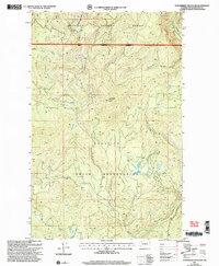
2001 Map of Strawberry Mountain
USGS Topo · Published 2004About this map
The Colville Indian Reservation and Okanogan National Forest converge in this high-altitude corner of Washington, where a complex network of drainages flows from prominent ridgelines. The land is defined by sharp elevation shifts, reaching its peak at the Strawberry Mountain Lookout and Central Peak. This 2001 revision illustrates the managed forest landscape, showing the National Forest Boundary and Indian Reservation Boundary as they divide these protected lands. A radial pattern of water sources, including Sheep Creek and Roaring Creek, underscores the area's role as a vital watershed. The map provides a detailed record of the forest access routes and remote landmarks like Dugout Mountain and Deerhorn at the turn of the 21st century.
Find a feature on this map
16 named features on this map. Tap any name to fly to it.
Don’t see what you’re looking for? This feature index may not catch every label — zoom into the map to look around manually.
Map Details
Editions of this 2001 Strawberry Mountain Map
This is the sole edition of this map. No revisions or reprints were ever made.
Other maps of this area

1902 · Osoyoos
USGS Topo · 1:125,000

1904 · Osoyoos
USGS Topo · 1:125,000

1904 · Republic
USGS Topo · 1:125,000

1951 · Wauconda
USGS Topo · 1:62,500

1952 · Disautel
USGS Topo · 1:62,500

1953 · Bald Knob
USGS Topo · 1:62,500

1954 · Okanogan
USGS Topo · 1:250,000

1957 · Aeneas Valley
USGS Topo · 1:62,500

1958 · Okanogan
USGS Topo · 1:250,000

1958 · Aeneas
USGS Topo · 1:62,500