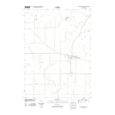
2010 Map of Strawberry Point
USGS Topo · Published 2010About this map
The town of Strawberry Point serves as the focal point of this Clayton County landscape, where the agricultural grid meets the winding course of the Maquoketa River. The town layout is anchored by the Strawberry Point Post Office and several local burial grounds, including the Strawberry Point Methodist Cemetery and Saint Marys Cemetery. Further north, the smaller settlement of Saint Sebald is defined by the Saint Sebald Lutheran Cemetery, representing the area's early German Lutheran heritage. The terrain transitions from flat farmland to more varied topography near Sugar Camp Hollow and the river valley, where Camp Ewalu occupies the wooded banks of the Maquoketa. Traces of early transportation routes are preserved in names like Old Mission Rd and Mission Rd, which cut diagonally across the standard section lines, while outlying sites like Reeds Cemetery and County Corners Cemetery mark the intersections of rural life.
Find a feature on this map
51 named features on this map. Tap any name to fly to it.
Don’t see what you’re looking for? This feature index may not catch every label — zoom into the map to look around manually.
Map Details
Editions of this 2010 Strawberry Point Map
This is the sole edition of this map. No revisions or reprints were ever made.
Other maps of this area

1901 · Oelwein
USGS Topo · 1:125,000

1902 · Elkader
USGS Topo · 1:125,000

1959 · Dubuque
USGS Topo · 1:250,000

1961 · Dubuque
USGS Topo · 1:250,000

1962 · Dubuque
USGS Topo · 1:250,000

1964 · Edgewood
USGS Topo · 1:24,000
1964 · Elkader
USGS Topo · 1:24,000

1965 · Wadena
USGS Topo · 1:24,000

1965 · Thorpe
USGS Topo · 1:24,000

1965 · Strawberry Point
USGS Topo · 1:24,000