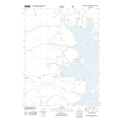
2011 Map of Strawberry Reservoir NW
USGS Topo · Published 2011About this map
Soldier Creek Reservoir dominates this landscape in the Wasatch Range, where early 21st-century water management and recreation meet. The map reveals the critical infrastructure of the Central Utah Project, most notably the Strawberry Tunnel which connects the West Portal and East Portal to divert water through Strawberry Ridge. This engineering feat is complemented by the Midview Dam, which helps regulate the vast high-mountain basin.
Find a feature on this map
35 named features on this map. Tap any name to fly to it.
Don’t see what you’re looking for? This feature index may not catch every label — zoom into the map to look around manually.
Map Details
Editions of this 2011 Strawberry Reservoir NW Map
This is the sole edition of this map. No revisions or reprints were ever made.
Other maps of this area

1885 · Salt Lake
USGS Topo · 1:250,000

1907 · Strawberry Valley
USGS Topo · 1:125,000

1909 · Strawberry Valley
USGS Topo · 1:125,000

1954 · Salt Lake City
USGS Topo · 1:250,000

1958 · Salt Lake City
USGS Topo · 1:250,000

1960 · Salt Lake City
USGS Topo · 1:250,000

1966 · Strawberry Reservoir NW
USGS Topo · 1:24,000
1966 · Strawberry Reservoir NE
USGS Topo · 1:24,000
1966 · Strawberry Reservoir SW
USGS Topo · 1:24,000

1967 · Two Tom Hill
USGS Topo · 1:24,000