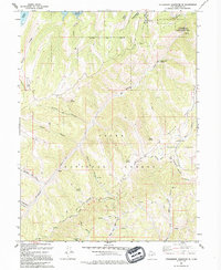
1993 Map of Strawberry Reservoir SE
USGS Topo · Published 1994About this map
The Strawberry State Wildlife Management Area and the high mountain terrain of the Uinta National Forest dominate this 1990s field-checked survey of the Wasatch region. The landscape is defined by a complex network of canyons and ridges, including Poison Ridge and Willow Creek Canyon, where numerous named springs like Poulson Spring and White Point Spring provide vital water sources in the high country.
Find a feature on this map
44 named features on this map. Tap any name to fly to it.
Don’t see what you’re looking for? This feature index may not catch every label — zoom into the map to look around manually.
Map Details
Editions of this 1993 Strawberry Reservoir SE Map
This is the sole edition of this map. No revisions or reprints were ever made.
Other maps of this area

1885 · Salt Lake
USGS Topo · 1:250,000

1885 · Manti
USGS Topo · 1:250,000

1885 · Uinta
USGS Topo · 1:250,000

1886 · Price River
USGS Topo · 1:250,000

1895 · Manti
USGS Topo · 1:250,000

1896 · Price River
USGS Topo · 1:250,000

1907 · Strawberry Valley
USGS Topo · 1:125,000

1909 · Strawberry Valley
USGS Topo · 1:125,000

1939 · Soldier Summit
USGS Topo · 1:62,500

1942 · Soldier Summit
USGS Topo · 1:62,500