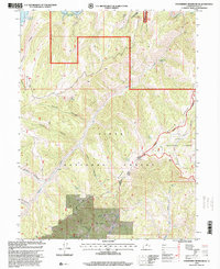
1996 Map of Strawberry Reservoir SE
USGS Topo · Published 2000About this map
The high-country terrain of the Wasatch Range is captured here as it appeared in the mid-1990s, dominated by the waters of the Strawberry Reservoir and the headwaters of the Strawberry River. This landscape is defined by the intersections of the Uinta National Forest and Ashley National Forest, where administrative boundaries meet at points like Stinking Springs Point and Badger Point. The map provides a detailed view of the remote drainage systems and canyons that feed the reservoir, including Center Canyon and French Hollow. Local navigation is largely restricted to the Willow Creek Road and various four-wheel-drive tracks that lead to isolated water sources such as Paulson Spring and Truck Spring. For those studying the management of Utah's public lands, the map clearly delineates the Heber and Spanish Fork Ranger Districts, alongside landmarks like Poison Ridge and Racetrack Hollow.
Find a feature on this map
30 named features on this map. Tap any name to fly to it.
Don’t see what you’re looking for? This feature index may not catch every label — zoom into the map to look around manually.
Map Details
Editions of this 1996 Strawberry Reservoir SE Map
This is the sole edition of this map. No revisions or reprints were ever made.
Other maps of this area

1885 · Salt Lake
USGS Topo · 1:250,000

1885 · Manti
USGS Topo · 1:250,000

1885 · Uinta
USGS Topo · 1:250,000

1886 · Price River
USGS Topo · 1:250,000

1895 · Manti
USGS Topo · 1:250,000

1896 · Price River
USGS Topo · 1:250,000

1907 · Strawberry Valley
USGS Topo · 1:125,000

1909 · Strawberry Valley
USGS Topo · 1:125,000

1939 · Soldier Summit
USGS Topo · 1:62,500

1942 · Soldier Summit
USGS Topo · 1:62,500