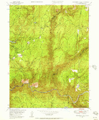
1948 Map of Strawberry Valley
USGS Topo · Published 1957About this map
Strawberry Valley and the surrounding gold-bearing canyons of the Sierra Nevada foothills are documented here during the late 1940s. The landscape is defined by the steep drainage of the North Fork Yuba River, where numerous historical river bars such as Wambo Bar, Kelly Bar, and the colorfully named Cut Eye Fosters Bar suggest a legacy of placer mining. The transition from active industry to history is evident in the labeling of the Palace Mine and Indian Hill Mine, reflecting the post-war state of traditional extraction in this part of the Tahoe National Forest.
Find a feature on this map
70 named features on this map. Tap any name to fly to it.
Don’t see what you’re looking for? This feature index may not catch every label — zoom into the map to look around manually.
Map Details
Editions of this 1948 Strawberry Valley Map
4 editions found
Other maps of this area

1888 · Smartsville
USGS Topo · 1:125,000

1888 · Bidwell Bar
USGS Topo · 1:125,000

1891 · Bidwell Bar
USGS Topo · 1:125,000

1891 · Downieville
USGS Topo · 1:125,000

1891 · Colfax
USGS Topo · 1:125,000

1891 · Smartsville
USGS Topo · 1:125,000

1892 · Smartsville
USGS Topo · 1:125,000

1892 · Colfax
USGS Topo · 1:125,000

1893 · Bidwell Bar
USGS Topo · 1:125,000

1893 · Downieville
USGS Topo · 1:125,000