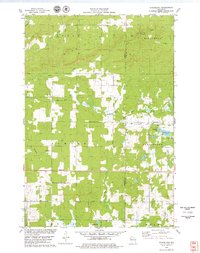
1978 Map of Strickland
USGS Topo · Published 1979About this map
Strickland and the surrounding timberlands of the Blue Hills define this landscape in the late 1970s. The region is characterized by its complex hydrology and glacial terrain, featuring the Doyle Hills and Wilkinson Hills rising above numerous water bodies like Perdziak Lake and Coudray Lake. The transportation network is anchored by the Soo Line, which connects the small settlements of Lehigh and Strickland, facilitating local industry and movement through the Barron and Rusk County borderlands.
Find a feature on this map
26 named features on this map. Tap any name to fly to it.
Don’t see what you’re looking for? This feature index may not catch every label — zoom into the map to look around manually.
Map Details
Editions of this 1978 Strickland Map
This is the sole edition of this map. No revisions or reprints were ever made.
Other maps of this area

1945 · Meteor
USGS Topo · 1:48,000

1948 · Weyerhauser
USGS Topo · 1:48,000

1949 · Meteor
USGS Topo · 1:48,000

1949 · Rice Lake
USGS Topo · 1:48,000

1950 · Weyerhauser
USGS Topo · 1:48,000

1951 · Rice Lake
USGS Topo · 1:48,000

1951 · Chetek
USGS Topo · 1:62,500

1953 · Rice Lake
USGS Topo · 1:250,000

1959 · Rice Lake
USGS Topo · 1:250,000

1965 · Rice Lake
USGS Topo · 1:62,500