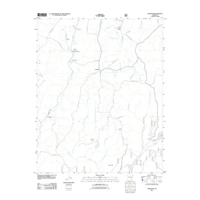
2011 Map of Strickler
USGS Topo · Published 2011About this map
Onda and Floss anchor this rural landscape in the Boston Mountains region, where a network of steep hollows and winding creek beds dictates the path of travel. The terrain is deeply dissected by the Illinois River and several significant tributaries, including Cove Creek and Fall Creek. For genealogists and local historians, the sheet is particularly valuable for its density of identified burial sites, including the Baker Cemetery, Scott Cemetery, Morrow Cemetery, Liberty Cemetery, and Dunkard Cemetery. These sites are linked by rugged routes like Bug Scuffle Rd and Onda Mountain Rd, reflecting the scattered settlement patterns of Washington County. Significant landmarks like Cherry Knob and the Dripping Spgs area provide fixed points of reference in a landscape characterized by dramatic elevation changes such as Chambers Hollow and Lick Hollow.
Find a feature on this map
48 named features on this map. Tap any name to fly to it.
Don’t see what you’re looking for? This feature index may not catch every label — zoom into the map to look around manually.
Map Details
Editions of this 2011 Strickler Map
This is the sole edition of this map. No revisions or reprints were ever made.
Other maps of this area

1898 · Winslow #4
USGS Topo · 1:62,500

1898 · Winslow #3
USGS Topo · 1:62,500

1898 · Winslow
USGS Topo · 1:125,000

1901 · Winslow
USGS Topo · 1:125,000

1946 · Fort Smith
USGS Topo · 1:250,000

1965 · Fort Smith
USGS Topo · 1:250,000

1967 · Fort Smith
USGS Topo · 1:250,000

1969 · Natural Dam
USGS Topo · 1:24,000
1969 · Mountainburg
USGS Topo · 1:24,000
1970 · Evansville
USGS Topo · 1:24,000