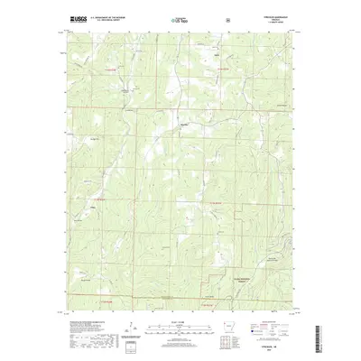
2020 Map of Strickler
USGS Topo · Published 2020About this map
The Ozark National Forest dominates the southern reaches of this Northwest Arkansas landscape, where the Boston Mountains descend into deep drainages. Settlement centers around Strickler and the small communities of Onda and Floss, connected by a network of rural routes like Stagecoach Rd and Durango Rd. Local history is preserved in a high density of rural burial grounds, including Scott Cem, Baker Cem, and Liberty Cem, which sit atop ridges or tucked into narrow valleys. The terrain is defined by rugged elevation changes, from the heights of Skylight Mtn down to the winding waters of the Illinois River and Cove Creek. The southeastern corner features the unique geological formation of Devils Den Natural Bridge, located along a system of hiking paths like the Yellow Rock Trail and Lake Trail.
Find a feature on this map
67 named features on this map. Tap any name to fly to it.
Don’t see what you’re looking for? This feature index may not catch every label — zoom into the map to look around manually.
Map Details
Editions of this 2020 Strickler Map
This is the sole edition of this map. No revisions or reprints were ever made.
Other maps of this area

1898 · Winslow #4
USGS Topo · 1:62,500

1898 · Winslow #3
USGS Topo · 1:62,500

1898 · Winslow
USGS Topo · 1:125,000

1901 · Winslow
USGS Topo · 1:125,000

1946 · Fort Smith
USGS Topo · 1:250,000

1965 · Fort Smith
USGS Topo · 1:250,000

1967 · Fort Smith
USGS Topo · 1:250,000

1969 · Natural Dam
USGS Topo · 1:24,000
1969 · Mountainburg
USGS Topo · 1:24,000
1970 · Evansville
USGS Topo · 1:24,000