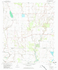
1967 Map of Stringtown
USGS Topo · Published 1982About this map
Grapeland and Stringtown anchor this landscape along the Indian Treaty Boundary, where the Delta's agricultural patterns are etched by a dense network of winding bayous and drainage channels. The 1967 topography reveals a deeply rural community defined by its spiritual and social anchors, including Strangers Rest Ch, Zion Field Ch, and the Rock of Ages Ch Cem. The intricate hydrology of the region is evident in the meanders of Steele Bayou, Stillwater Bayou, and Snake Bayou, which segment the leveled fields and landing strips. This survey documents the area just before significant modern consolidation, preserving the locations of numerous small churches like Kindling Altar Ch and family-named landmarks like Dickerson Cem that serve as vital touchstones for Delta genealogy and local history.
Find a feature on this map
44 named features on this map. Tap any name to fly to it.
Don’t see what you’re looking for? This feature index may not catch every label — zoom into the map to look around manually.
Map Details
Editions of this 1967 Stringtown Map
2 editions found
Other maps of this area

1933 · Lamont
USGS Topo · 1:62,500

1939 · Refuge
USGS Topo · 1:62,500

1939 · Lamont
USGS Topo · 1:62,500

1939 · Tralake
USGS Topo · 1:62,500

1939 · Choctaw
USGS Topo · 1:62,500

1953 · Greenwood
USGS Topo · 1:250,000

1956 · Greenwood
USGS Topo · 1:250,000

1967 · Stringtown
USGS Topo · 1:24,000
1967 · Skene
USGS Topo · 1:24,000

1967 · Leland
USGS Topo · 1:24,000