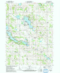
1993 Map of Stroh
USGS Topo · Published 1993About this map
Big Turkey Lake and a dense network of surrounding kettle lakes dominate this Northeastern Indiana landscape, where the borders of Lagrange, Steuben, Noble, and Dekalb counties converge. The mapping reveals a distinct pattern of lakeside development, from the established community of Stroh to seasonal clusters like Oak Lodge, Lakeside Park, and Meadow Shores Park. Small rural hubs such as Salem Center and Helmer serve the surrounding agricultural districts, connected by a grid of county roads that navigate between wetlands like Goose Pond and Duck Pond. Local heritage is anchored by sites like the Milford Sch, Lake Bethel Ch, and the Weston Chapel Cem. The presence of several gaging and pumping stations underscores the importance of water management in this marshy, lake-rich region during the early 1990s.
Find a feature on this map
66 named features on this map. Tap any name to fly to it.
Don’t see what you’re looking for? This feature index may not catch every label — zoom into the map to look around manually.
Map Details
Editions of this 1993 Stroh Map
This is the sole edition of this map. No revisions or reprints were ever made.
Other maps of this area

1940 · Orland
USGS Topo · 1:24,000

1941 · Orland
USGS Topo · 1:24,000

1941 · Angola West
USGS Topo · 1:24,000

1942 · Ashley
USGS Topo · 1:24,000

1942 · Angola West
USGS Topo · 1:24,000

1942 · Stroh
USGS Topo · 1:24,000

1947 · Mongo
USGS Topo · 1:24,000

1947 · Wolcottville
USGS Topo · 1:24,000

1953 · Fort Wayne
USGS Topo · 1:250,000

1955 · Corunna
USGS Topo · 1:24,000