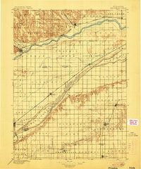
1896 Map of Stromsburg
USGS Topo · Published 1906About this map
The Platte River valley and its surrounding prairies define this late-nineteenth-century landscape, where river braids and railroad lines dictated the placement of emerging Nebraska settlements. Established towns like Fullerton and Osceola sit amid a grid of townships, while the Union Pacific R.R. follows the riverbank to serve hubs such as Silver Creek and Clarks. The map reveals the intricate water network of the region, from the wide Loup River in the north to the Big Blue River and Arborville in the south.
Find a feature on this map
49 named features on this map. Tap any name to fly to it.
Don’t see what you’re looking for? This feature index may not catch every label — zoom into the map to look around manually.
Map Details
Editions of this 1896 Stromsburg Map
5 editions found
Other maps of this area

1896 · Stromsburg
USGS Topo · 1:125,000

1898 · York
USGS Topo · 1:125,000

1898 · Grand Island
USGS Topo · 1:125,000

1899 · David City
USGS Topo · 1:125,000

1899 · St. Paul
USGS Topo · 1:125,000

1899 · York
USGS Topo · 1:125,000

1934 · Utica
USGS Topo · 1:62,500

1937 · Utica
USGS Topo · 1:62,500

1954 · Belgrade
USGS Topo · 1:24,000

1954 · Cedar Rapids SE
USGS Topo · 1:24,000