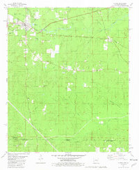
1981 Map of Strong
USGS Topo · Published 1981About this map
Strong serves as the focal point of this Union County region, where the Missouri Pacific railroad cuts a diagonal line through the town and the surrounding bottomlands. The landscape is defined by the convergence of several waterways, including North Lapile Creek and South Lapile Creek, which feed into the primary Lapile Creek system. This area demonstrates a mix of industrial and rural development, notably featuring the Strong Oil Field and localized settlements like Gardner and Victoria.
Find a feature on this map
36 named features on this map. Tap any name to fly to it.
Don’t see what you’re looking for? This feature index may not catch every label — zoom into the map to look around manually.
Map Details
Editions of this 1981 Strong Map
This is the sole edition of this map. No revisions or reprints were ever made.
Other maps of this area

1933 · Strong
USGS Topo · 1:62,500

1934 · Felsenthal
USGS Topo · 1:62,500

1935 · Haile
USGS Topo · 1:62,500

1937 · Strong
USGS Topo · 1:62,500

1937 · Felsenthal
USGS Topo · 1:62,500

1938 · Felsenthal
USGS Topo · 1:62,500

1939 · Felsenthal
USGS Topo · 1:62,500

1939 · Strong
USGS Topo · 1:62,500

1952 · Farmerville
USGS Topo · 1:62,500

1953 · El Dorado
USGS Topo · 1:250,000