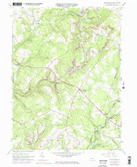
1961 Map of Strongstown
USGS Topo · Published 1983About this map
The coal and timber country of Indiana and Cambria Counties comes into focus through this survey, showing a landscape defined by industry and rural tradition. The northern reaches of the map are anchored by the mining community of Heilwood, where a Mine Dump and Strip Mine operations mark the terrain near Yellow Creek. This economic engine is balanced by a dense network of country churches and burial grounds, including the Spruce Grove Ch and Pine Land Cem, which served the dispersed families of the Pine and Buffington townships.
Find a feature on this map
47 named features on this map. Tap any name to fly to it.
Don’t see what you’re looking for? This feature index may not catch every label — zoom into the map to look around manually.
Map Details
Editions of this 1961 Strongstown Map
4 editions found
Other maps of this area

1902 · Indiana
USGS Topo · 1:62,500

1902 · Barnesboro
USGS Topo · 1:62,500

1904 · Barnesboro
USGS Topo · 1:62,500

1904 · Johnstown
USGS Topo · 1:62,500

1907 · Johnstown
USGS Topo · 1:62,500

1920 · New Florence
USGS Topo · 1:62,500

1921 · New Florence
USGS Topo · 1:48,000

1922 · New Florence
USGS Topo · 1:62,500

1943 · Punxsutawney
USGS Topo · 1:125,000

1944 · New Florence
USGS Topo · 1:62,500
Featured Places
- Brush Valley Township, PA
- Ewings Mill, Cherryhill Township
- Strongstown, Pine Township
- Cherryhill Township, PA
- Blacklick Township, PA