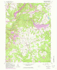
1963 Map of Brush Valley
USGS Topo · Published 1982About this map
The confluence of coal extraction and modern water management defines this portion of Indiana County in the early 1960s. Yellow Creek Lake and Lick Two Lick Reservoir dominate the landscape, providing recreational and industrial resources near the community of Brush Valley. The presence of numerous Strip Mines and a Tipple near Strongs Hill underscores the region's reliance on mining, while the Yellow Creek Railroad provided the necessary transport for extracted resources.
Find a feature on this map
48 named features on this map. Tap any name to fly to it.
Don’t see what you’re looking for? This feature index may not catch every label — zoom into the map to look around manually.
Map Details
Editions of this 1963 Brush Valley Map
4 editions found
Other maps of this area

1902 · Indiana
USGS Topo · 1:62,500

1902 · Barnesboro
USGS Topo · 1:62,500

1904 · Barnesboro
USGS Topo · 1:62,500

1904 · Johnstown
USGS Topo · 1:62,500

1907 · Johnstown
USGS Topo · 1:62,500

1920 · New Florence
USGS Topo · 1:62,500

1921 · New Florence
USGS Topo · 1:48,000

1922 · New Florence
USGS Topo · 1:62,500

1943 · Punxsutawney
USGS Topo · 1:125,000

1944 · New Florence
USGS Topo · 1:62,500
Featured Places
- Brush Valley Township, PA
- Rico, Brush Valley Township
- Center Township, PA
- Suncliff, Brush Valley Township
- Cherryhill Township, PA