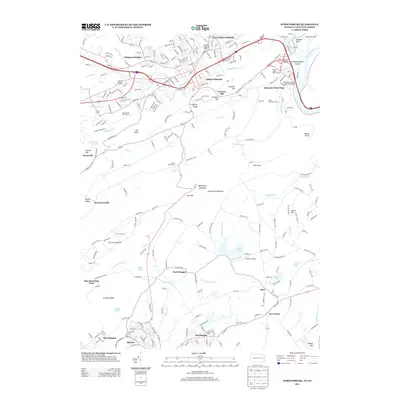
2013 Map of Stroudsburg
USGS Topo · Published 2013About this map
Stroudsburg and East Stroudsburg serve as the primary hubs of development where Brodhead Creek meets McMichael Creek, demonstrating the dense residential and commercial expansion of the early 21st century. The landscape is dominated by the dramatic elevation changes of Kittatinny Mountain, which creates a natural barrier between the northern urban centers and the southern borough of Roseto. This geological divide is punctuated by natural crossings like Fox Gap and Totts Gap, which historically dictated the flow of transport and trade. To the south, the map reveals a distinct pattern of smaller industrial and residential clusters, including East Bangor and North Bangor, tied to the valley's slate-quarrying legacy. Water features like Minsi Lake and the Delaware River define the eastern boundaries, while landmarks such as Hallett's Airport and numerous camps like Camp Big Pocono highlight the area's role as a regional recreation and aviation waypoint.
Find a feature on this map
62 named features on this map. Tap any name to fly to it.
Don’t see what you’re looking for? This feature index may not catch every label — zoom into the map to look around manually.
Map Details
Editions of this 2013 Stroudsburg Map
This is the sole edition of this map. No revisions or reprints were ever made.
Other maps of this area

1891 · Delaware Water Gap
USGS Topo · 1:62,500

1893 · Delaware Water Gap
USGS Topo · 1:62,500

1914 · Wind Gap
USGS Topo · 1:62,500

1916 · Wind Gap
USGS Topo · 1:62,500

1919 · Pocono
USGS Topo · 1:62,500

1921 · Pocono
USGS Topo · 1:62,500

1923 · Pocono
USGS Topo · 1:62,500

1924 · Bushkill
USGS Topo · 1:48,000

1936 · Delaware Water Gap
USGS Topo · 1:48,000

1941 · Delaware Water Gap
USGS Topo · 1:62,500