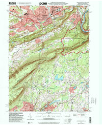
1999 Map of Stroudsburg
USGS Topo · Published 2001About this map
Stroudsburg and East Stroudsburg serve as the urban heart of this Pennsylvania landscape at the turn of the millennium, where the Delaware River carves its famous path through Kittatinny Mountain. The topography transitions from the developed valley floors, where the State Teachers College and various neighborhood schools like St Matthew Sch are situated, to the high ridges of Godfrey Ridge and Blue Mountain.
Find a feature on this map
72 named features on this map. Tap any name to fly to it.
Don’t see what you’re looking for? This feature index may not catch every label — zoom into the map to look around manually.
Map Details
Editions of this 1999 Stroudsburg Map
This is the sole edition of this map. No revisions or reprints were ever made.
Other maps of this area

1891 · Delaware Water Gap
USGS Topo · 1:62,500

1893 · Delaware Water Gap
USGS Topo · 1:62,500

1914 · Wind Gap
USGS Topo · 1:62,500

1916 · Wind Gap
USGS Topo · 1:62,500

1919 · Pocono
USGS Topo · 1:62,500

1921 · Pocono
USGS Topo · 1:62,500

1923 · Pocono
USGS Topo · 1:62,500

1924 · Bushkill
USGS Topo · 1:48,000

1936 · Delaware Water Gap
USGS Topo · 1:48,000

1941 · Delaware Water Gap
USGS Topo · 1:62,500