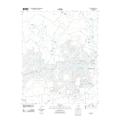
2011 Map of Stuart
USGS Topo · Published 2011About this map
Cherokee Village and its intricate network of residential streets and man-made lakes dominate this Ozark foothills landscape, showcasing the area's mid-century evolution into a major planned community. The development is centered around complex water systems including Lake Thunderbird, Lake Omaha, and Lake Chanute, which were created by damming local tributaries. Older rural patterns remain visible through several family burial grounds such as Wavrick Cemetery and Hersperger Cemetery, as well as named creek crossings like Baker Ford and Slick Rock Ford on the South Fork Spring River. The presence of numerous youth camps, such as Camp Kia Kima and Camp Miramichee, alongside the Cherokee Village Airport, highlights the region's transition into a destination for recreation and retirement. Smaller nearby settlements like Highland and Stuart anchor the southern portion of the map, providing a contrast to the dense winding roads of the primary resort village.
Find a feature on this map
81 named features on this map. Tap any name to fly to it.
Don’t see what you’re looking for? This feature index may not catch every label — zoom into the map to look around manually.
Map Details
Editions of this 2011 Stuart Map
This is the sole edition of this map. No revisions or reprints were ever made.
Other maps of this area

1957 · Poplar Bluff
USGS Topo · 1:250,000

1959 · Poplar Bluff
USGS Topo · 1:250,000

1960 · Poplar Bluff
USGS Topo · 1:250,000

1962 · Stuart
USGS Topo · 1:24,000

1962 · Ash Flat
USGS Topo · 1:24,000

1962 · Myron
USGS Topo · 1:24,000

1962 · Agnos
USGS Topo · 1:24,000

1962 · Mammoth Spring
USGS Topo · 1:24,000
1962 · Camp
USGS Topo · 1:24,000

1968 · Hardy
USGS Topo · 1:24,000