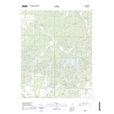
2023 Map of Stuart
USGS Topo · Published 2023About this map
Cherokee Village and its network of planned lakes dominate the center of this modern survey, where the South Fork Spring River and Big Otter Creek converge. The landscape is defined by extensive residential platting around water bodies like Lake Thunderbird, Lake Omaha, and Lake Chanute, contrasting with the more rural terrain to the north near 9 Mile Ridge. Local history and infrastructure are represented by the Oaklawn Cem and the Sharp County Regional Airport near Highland. To the south, Ozarka College anchors the community of Ash Flat, while the eastern edge transition into Hardy near the Spring River. This survey captures a highly developed recreational and residential corridor in the Ozark foothills, characterized by complex road networks such as Chickasha Dr and Santee Dr that follow the winding lakefronts.
Find a feature on this map
315 named features on this map. Tap any name to fly to it.
Don’t see what you’re looking for? This feature index may not catch every label — zoom into the map to look around manually.
Map Details
Editions of this 2023 Stuart Map
This is the sole edition of this map. No revisions or reprints were ever made.
Other maps of this area

1957 · Poplar Bluff
USGS Topo · 1:250,000

1959 · Poplar Bluff
USGS Topo · 1:250,000

1960 · Poplar Bluff
USGS Topo · 1:250,000

1962 · Stuart
USGS Topo · 1:24,000

1962 · Ash Flat
USGS Topo · 1:24,000

1962 · Myron
USGS Topo · 1:24,000

1962 · Agnos
USGS Topo · 1:24,000

1962 · Mammoth Spring
USGS Topo · 1:24,000
1962 · Camp
USGS Topo · 1:24,000

1968 · Hardy
USGS Topo · 1:24,000