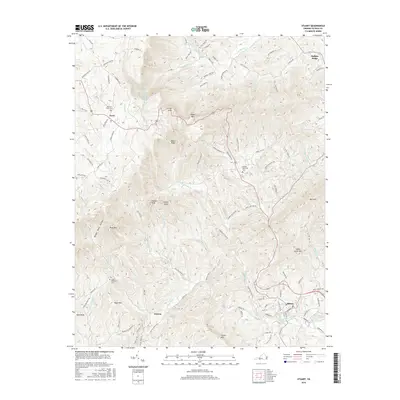
2016 Map of Stuart
USGS Topo · Published 2016About this map
Stuart serves as a primary hub in this mountainous corner of Southwest Virginia, where the land rises sharply toward the Blue Ridge. The terrain is defined by a series of prominent peaks and ridges, including Buffalo Ridge and Indian Grave Mtn, which overlook a complex drainage network. The S Mayo River and the South Mayo River converge near the town, while to the north, the headwaters of the Smith River carve through deep hollows. Smaller settlements like Vesta and Dobyns are connected by winding mountain roads such as Dobyns Rd and State Rte 619. Genealogists may find value in the locations of the Bouldin Memorial Cem and Mayo Mountain Cem, which are situated on the slopes near the watercourses. The inclusion of landmark names like Lovers Leap and Naked Ridge highlights the distinctive topography that has long shaped the local identity and travel patterns of Patrick County.
Find a feature on this map
110 named features on this map. Tap any name to fly to it.
Don’t see what you’re looking for? This feature index may not catch every label — zoom into the map to look around manually.
Map Details
Editions of this 2016 Stuart Map
This is the sole edition of this map. No revisions or reprints were ever made.
Other maps of this area

1926 · Critz
USGS Topo · 1:48,000

1928 · Stuart
USGS Topo · 1:48,000

1928 · Critz
USGS Topo · 1:62,500

1931 · Stuart
USGS Topo · 1:62,500

1953 · Winston-Salem
USGS Topo · 1:250,000

1955 · Winston-Salem
USGS Topo · 1:250,000

1957 · Endicott
USGS Topo · 1:62,500

1957 · Floyd
USGS Topo · 1:62,500

1962 · Winston-Salem
USGS Topo · 1:250,000

1967 · Patrick Springs
USGS Topo · 1:24,000