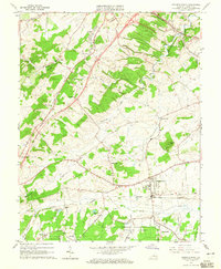
1964 Map of Stuarts Draft
USGS Topo · Published 1965About this map
Stuarts Draft stands as a focal point of this mid-1960s landscape, situated along the Norfolk and Western railroad and the South River. The map illustrates a period of infrastructure expansion, prominently showing a section of road under construction and an old grade near Mint Spring. This transition is set against a deeply rooted rural backdrop defined by family and community landmarks such as Cochran Church, Oak Grove Church, and Hammond Cemetery. To the south, the boundary of the George Washington National Forest meets the headwaters of several drainages, including Johns Run and Falling Rock Creek. Small water bodies like Hattons Pond and Lake Wilda dot the terrain, while settlements such as White Hill, Joliyue, and Rivermont reflect the established residential pattern of Augusta County during this era.
Find a feature on this map
50 named features on this map. Tap any name to fly to it.
Don’t see what you’re looking for? This feature index may not catch every label — zoom into the map to look around manually.
Map Details
Editions of this 1964 Stuarts Draft Map
3 editions found

Other maps of this area

1892 · Buckingham
USGS Topo · 1:125,000

1892 · Harrisonburg
USGS Topo · 1:125,000

1894 · Staunton
USGS Topo · 1:125,000

1894 · Lexington
USGS Topo · 1:125,000

1934 · Waynesboro
USGS Topo · 1:48,000

1936 · Vesuvius
USGS Topo · 1:48,000

1939 · Waynesboro
USGS Topo · 1:62,500

1941 · Vesuvius
USGS Topo · 1:62,500

1943 · Lovingston
USGS Topo · 1:62,500

1944 · Staunton
USGS Topo · 1:62,500