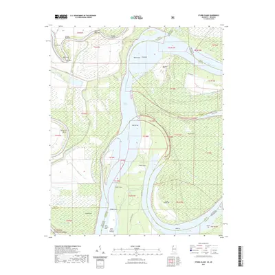
2021 Map of Stubbs Island
USGS Topo · Published 2021About this map
The Mississippi River defines the shifting boundary between Arkansas and Mississippi in this riverine study, carving out a complex system of bars, points, and secondary channels. The Hardin Cut-Off illustrates the river's tendency to reshape itself, creating isolated landforms like Stubbs Island and Island Number 58. Along the western bank, the Saint Francis River flows toward its confluence, bordered by the southern reaches of the St. Francis National Forest. This low-lying landscape is punctuated by numerous oxbow remnants and floodplain depressions, including Laddie Lake, Coker Lake, and Tunica Lake. Narrow corridors such as Kate Adams Chute provide a look at the historical navigation routes used before modern channel stabilization. These features, along with named river hazards like Shoo Fly Bar and Austin Bar, document the evolving hydrology of the Delta region.
Find a feature on this map
59 named features on this map. Tap any name to fly to it.
Don’t see what you’re looking for? This feature index may not catch every label — zoom into the map to look around manually.
Map Details
Editions of this 2021 Stubbs Island Map
This is the sole edition of this map. No revisions or reprints were ever made.
Other maps of this area

1908 · Dundee
USGS Topo · 1:24,000

1910 · Dundee
USGS Topo · 1:31,680

1931 · Horseshoe Lake
USGS Topo · 1:62,500

1939 · Clayton
USGS Topo · 1:62,500

1939 · Horseshoe Lake
USGS Topo · 1:62,500

1939 · Park Place
USGS Topo · 1:62,500

1939 · Latour
USGS Topo · 1:62,500

1948 · Helena
USGS Topo · 1:250,000

1950 · Helena
USGS Topo · 1:250,000

1954 · Horseshoe Lake
USGS Topo · 1:62,500
Featured Places
- Saint Francis Island Landing, AR
- Harbert Landing, MS
- Phillips County, AR
- Tunica County, MS
- Lee County, AR