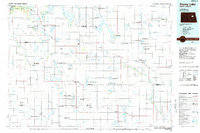
1985 Map of Stump Lake
USGS Topo · Published 1985About this map
Stump Lake and the eastern reaches of Devils Lake dominate this mid-1980s landscape, illustrating a region defined by its glacial hydrology and wildlife conservation. Much of the northwestern portion is occupied by the Fort Totten Indian Reservation, featuring settlements such as Fort Totten, Tokio, and Saint Michael. The map details a complex network of sloughs and lakes, many protected within the Stump Lake National Wildlife Refuge and Sullys Hill National Wildlife Refuge. The Burlington Northern railroad serves as the primary transit corridor, linking agricultural towns like Warwick, Pekin, and McVille. This planimetric study shows the transition of the Sheyenne River as it winds through the southern townships, while landmarks like Devils Heart Butte and Lookout Mountain provide vertical contrast to the surrounding flats and coulees.
Find a feature on this map
110 named features on this map. Tap any name to fly to it.
Don’t see what you’re looking for? This feature index may not catch every label — zoom into the map to look around manually.
Map Details
Editions of this 1985 Stump Lake Map
2 editions found
Other maps of this area

1900 · Pingree
USGS Topo · 1:125,000

1928 · Tokio
USGS Topo · 1:62,500

1930 · Pekin
USGS Topo · 1:62,500

1930 · Hamar
USGS Topo · 1:62,500

1931 · Oberon
USGS Topo · 1:62,500

1931 · Tokio
USGS Topo · 1:62,500

1931 · Devils Lake
USGS Topo · 1:62,500

1932 · Grahams Island
USGS Topo · 1:62,500

1939 · Niagara
USGS Topo · 1:62,500

1942 · McVille
USGS Topo · 1:62,500