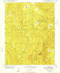
1948 Map of Stumpfield Mountain
USGS Topo · Published 1948About this map
Stumpfield Mountain and the surrounding high country of the Sierra National Forest dominate this late-1940s landscape at the boundary of Mariposa and Madera counties. The drainage network of the Chowchilla River and its various branches, including the West Fork and East Fork, dictates the early settlement pattern. Human activity is concentrated along these watercourses and ridgelines, evidenced by the presence of small rural infrastructure like the Chowchilla School and the Indian Peak School near the southern boundary.
Find a feature on this map
32 named features on this map. Tap any name to fly to it.
Don’t see what you’re looking for? This feature index may not catch every label — zoom into the map to look around manually.
Map Details
Editions of this 1948 Stumpfield Mountain Map
3 editions found
Other maps of this area

1897 · Yosemite
USGS Topo · 1:125,000

1900 · Yosemite
USGS Topo · 1:125,000

1903 · Yosemite
USGS Topo · 1:125,000

1909 · Yosemite
USGS Topo · 1:125,000

1912 · Mariposa
USGS Topo · 1:125,000

1947 · Mariposa
USGS Topo · 1:24,000

1947 · Mariposa
USGS Topo · 1:250,000

1947 · El Portal
USGS Topo · 1:62,500

1947 · Mariposa
USGS Topo · 1:62,500

1947 · Buckingham Mtn
USGS Topo · 1:24,000