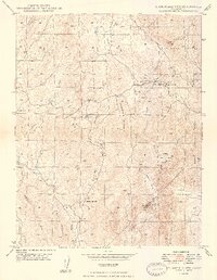
1948 Map of Stumpfield Mtn.
USGS Topo · Published 1948About this map
Chowchilla River and its various forks dominate this 1940s landscape, illustrating a topography defined by significant drainages and high peaks on the border of Mariposa and Madera Counties. The map records a sparsely populated region of the Sierra National Forest, where rural infrastructure is anchored by local landmarks like Elliott Corner and Magoon Hill. Educational centers such as Chowchilla Sch and Indian Peak Sch appear as primary community nodes in a terrain otherwise characterized by steep ridges and named peaks like Stumpfield Mountain and Miami Mtn. Small-scale evidence of early habitation includes a Cem near Magoon Creek and named features like Metcalf Gap, providing a detailed view of the Sierra foothills before modern development altered the road networks and rural character.
Find a feature on this map
33 named features on this map. Tap any name to fly to it.
Don’t see what you’re looking for? This feature index may not catch every label — zoom into the map to look around manually.
Map Details
Editions of this 1948 Stumpfield Mtn. Map
3 editions found
Other maps of this area

1897 · Yosemite
USGS Topo · 1:125,000

1900 · Yosemite
USGS Topo · 1:125,000

1903 · Yosemite
USGS Topo · 1:125,000

1909 · Yosemite
USGS Topo · 1:125,000

1912 · Mariposa
USGS Topo · 1:125,000

1947 · Mariposa
USGS Topo · 1:24,000

1947 · Mariposa
USGS Topo · 1:250,000

1947 · El Portal
USGS Topo · 1:62,500

1947 · Mariposa
USGS Topo · 1:62,500

1947 · Buckingham Mtn
USGS Topo · 1:24,000