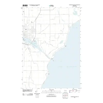
2010 Map of Sturgeon Bay East
USGS Topo · Published 2010About this map
Saint Joseph Cemetery sits near the northern outskirts of the city where the Door Peninsula narrows, marking a landscape defined by its vital maritime corridors. This area is centered on the artificial Sturgeon Bay Ship Canal, a critical engineering feat that links the protected waters of Sturgeon Bay to the open expanse of Lake Michigan. The map details the infrastructure of a working waterfront and recreation hub, from the Sturgeon Bay Canal Light guarding the eastern entrance to the Sturgeon Yacht Harbor and Snug Harbor Yacht Basin in the interior. Inland, the terrain rises toward Mount Lowe and Stevens Hill, while the eastern shore is dotted with family-named coastal features like Portage Point and Lilly Bay. The drainage of Lilly Bay Creek and Donlans Creek into Dunes Lake illustrates the complex hydrology of this shoreline environment.
Find a feature on this map
56 named features on this map. Tap any name to fly to it.
Don’t see what you’re looking for? This feature index may not catch every label — zoom into the map to look around manually.
Map Details
Editions of this 2010 Sturgeon Bay East Map
This is the sole edition of this map. No revisions or reprints were ever made.
Other maps of this area

1954 · Manitowoc
USGS Topo · 1:250,000

1958 · Manitowoc
USGS Topo · 1:250,000

1960 · Sturgeon Bay
USGS Topo · 1:62,500

1960 · Jacksonport
USGS Topo · 1:62,500

1960 · Algoma
USGS Topo · 1:62,500

1981 · Sturgeon Bay West
USGS Topo · 1:24,000

1981 · Institute
USGS Topo · 1:24,000
1981 · Idlewild
USGS Topo · 1:24,000
1981 · Sturgeon Bay East
USGS Topo · 1:24,000
1982 · Jacksonport
USGS Topo · 1:24,000