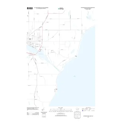
2013 Map of Sturgeon Bay East
USGS Topo · Published 2013About this map
Sturgeon Bay and its vital maritime connection to Lake Michigan dominate this 2013 landscape, where the Sturgeon Bay Ship Canal bisects the Door County peninsula. The map illustrates a transition from the urbanized streets of Stevens Hill and the recreation-focused Snug Harbor Yacht Basin to the agricultural and natural lands of the east. Local geography is defined by prominent coastal markers like Portage Point and Rocky Point, while the interior shows the agricultural footprint of Robertson Orchards. Natural water systems including Dunes Lake and Geisel Creek remain prominent near the lakeshore. The road network, anchored by State Highway 42 57, reveals how modern transit overlays an older grid of country roads and residential lanes that follow the irregular contours of the bay and the Lake Michigan coast.
Find a feature on this map
70 named features on this map. Tap any name to fly to it.
Don’t see what you’re looking for? This feature index may not catch every label — zoom into the map to look around manually.
Map Details
Editions of this 2013 Sturgeon Bay East Map
This is the sole edition of this map. No revisions or reprints were ever made.
Other maps of this area

1954 · Manitowoc
USGS Topo · 1:250,000

1958 · Manitowoc
USGS Topo · 1:250,000

1960 · Sturgeon Bay
USGS Topo · 1:62,500

1960 · Jacksonport
USGS Topo · 1:62,500

1960 · Algoma
USGS Topo · 1:62,500

1981 · Sturgeon Bay West
USGS Topo · 1:24,000

1981 · Institute
USGS Topo · 1:24,000
1981 · Idlewild
USGS Topo · 1:24,000
1981 · Sturgeon Bay East
USGS Topo · 1:24,000
1982 · Jacksonport
USGS Topo · 1:24,000